A 40-Year Historic Low On The Mississippi
You may have noticed that for a time, blog posts will appear oftener than the regular Tuesday and Friday. Why? Because I could not blog for a month? Why? I'd installed what I thought would be a good extension (Web Ad Blocker) and thanks to Julie Rosenoff and Connie Bunch who diagnosed the problem (I NEVER WOULD HAVE!) I'm back to work and catching up with posting. Clear as Mississippi Mud?
Last October, 2022, I was blessed to take a cruise down the entire length of the Mississippi River...... from St. Paul to New Orleans. All the shipboard chatter was that the river was at a historic 40-year low. My first thought, ignorantly formed, was is this a big deal? The answer was absolutely this was a huge big deal.
We were told that our ship drew 7-feet of water (a hotel atop a barge, really). The river was only 9.5-feet in some places!! We were told by the Corps of Engineers a couple of times to "pull over and tie up until further notice" because of dredging downstream. A couple of times the river "was closed ahead until further notice." And our planned stops were rearranged and we did miss a couple. Inconvenienced cruise ship passengers is one teeny part of the situation.
The Mississippi River is chock-a-block full of barges; huge rafts of barges (sometimes 5 abreast and 6 or 7 long) were being pushed by tugboats up and down the river. Of course they were stopped too. THIS was the real sticky-wicket. Most of the food grown along the river is shipped by these barges down to New Orleans. Nearly 3/4s we were told. If this food cannot get on its way in a timely fashion....... well, just imagine the problems. Food goes downriver; fuel oil, gasoline and other commodities come upriver. Simplifying this a bit, of course.
Aaron, our educational guy, quipped that between Baton Rouge and New Orleans the mile-wide Mississippi was "just a parking lot for boats and barges with a stream running through it." And all these boats and barges have stuff on them desperately trying to get to market.
You now can imagine that with the river at a 40-year low, and the channel squeezed smaller, and huge sandy banks out of water on both sides that river traffic is compromised. But the Corps of Engineers keep it going, bless their hearts.
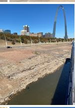
The photo above I took from our ship where we were moored just below the Gateway Arch in St. Louis. Just above the car is the access road and while you cannot see them, right in front of the Arch are a huge flight of stone steps which sometimes go right down to the water's edge. Not in 2022! I'm no good at judging distances, but just by the size of that car, imagine how LOW the river is there.


Comments
Post a Comment